
Odisha Confronts Multi-Hazard Situation as 1 Million Evacuated Ahead of Cyclone Dana. South Bengal Prepares for Heavy Rains, Train Services Canceled, and Kolkata Airport to Suspend Operations.
Table of Contents
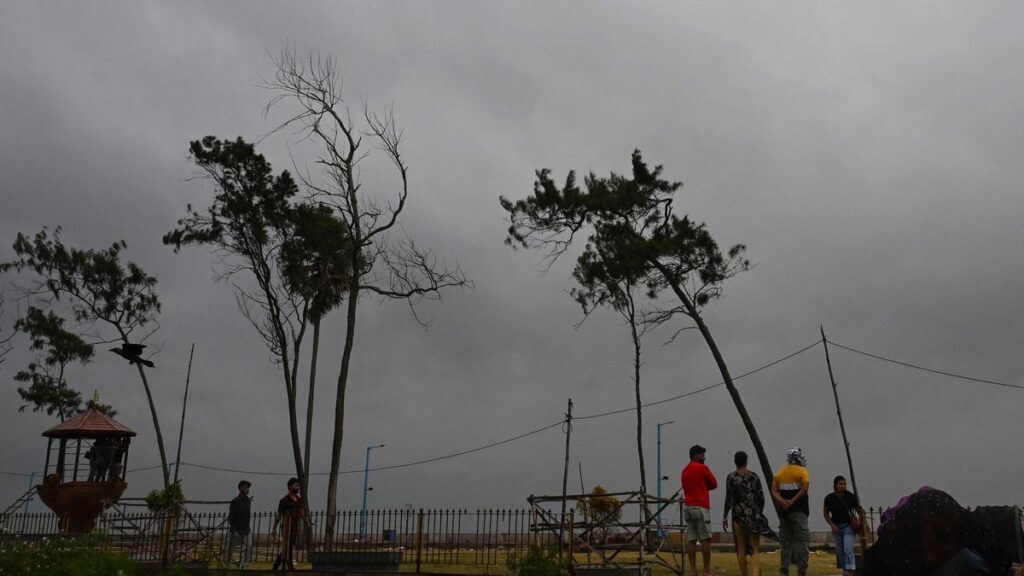
Individuals navigate through strong winds as they approach the Dhamara fishing harbor in anticipation of cyclone Dana’s landfall in the Bhadrak district of Odisha on Thursday.

The severe cyclonic storm ‘Dana’ is projected to make landfall between Bhitarkanika National Park and Dhamra Port in Odisha early Friday, with wind speeds reaching up to 120 kilometers per hour (kmph).
According to the Indian Meteorological Department (IMD), numerous coastal districts in Odisha and Southern West Bengal are expected to experience heavy to very heavy rainfall. The cyclone will also bring significant rainfall to certain areas of Jharkhand.
On Thursday morning, Odisha’s coastal region faced intense rain and gusty winds as the storm drew nearer, as reported by the IMD. The highest recorded rainfall was 62 mm at Paradip, while Rajnagar in Kendrapara district saw 24 mm of rain within the last four hours, according to the Met Department.
Manorama Mohanty, Director of the Regional Meteorological Centre in Bhubaneswar, stated: “The severe cyclonic storm is anticipated to slightly re-curve towards the west and west-southwest after making landfall, resulting in rainfall in southern Odisha around October 26.”
Coastal Odisha, parts of Bengal receive heavy rain; flights, trains suspended….
KEY DEVELOPMENTS
- (Odisha) Affected Areas:
Kendrapara, Bhadrak, and Balasore have been identified as high-risk zones, with wind speeds potentially reaching 120 kmph and a tidal surge of up to 2 meters expected.
Extremely heavy rainfall is forecasted for Balasore, Mayurbhanj, and Jajpur, while light to moderate rain is anticipated in other regions of Odisha, with significant rainfall commencing on the evening of October 23.
The Odisha government aims to relocate 1 million individuals from coastal regions; approximately 300,000 to 400,000 were evacuated by Wednesday evening, with the remainder scheduled for relocation by Thursday.
All marine activities, including fishing, have been suspended until the cyclone has passed, and all fishermen returned safely by Tuesday.
2. (Bengal) Impact Zones:
Forecasts indicate heavy to very heavy rainfall across several districts, with certain isolated regions potentially experiencing extremely heavy rainfall exceeding 21 cm.
Coastal districts such as South 24 Parganas, East Midnapore, and Howrah are under significant threat due to anticipated strong winds ranging from 100 to 110 km/h and tidal surges.
North 24 Parganas, Kolkata, Hooghly, and Nadia are expected to encounter heavy to very heavy rainfall, which may result in localized flooding in vulnerable low-lying areas.
Kolkata airport will halt flight operations for 15 hours starting at 6 PM on Thursday due to the anticipated effects of the cyclone.
3. (Jharkhand) Impact Zones
The southern and eastern districts, particularly East Singhbhum, West Singhbhum, and Saraikela-Kharsawan, are projected to be the most impacted by heavy rainfall and strong winds.
Regions adjacent to rivers in East Singhbhum and Dumka may experience localized flooding as a result of the expected precipitation.
Winds reaching speeds of 60 to 70 km/h, combined with heavy rainfall, could affect districts such as Ranchi, Bokaro, and Dhanbad, potentially leading to infrastructure damage and waterlogging.
Cyclone ‘Dana’ in ODISHA
The weather system over the Bay of Bengal has progressed north-northwestward at a speed of 12 km/h over the last six hours, currently situated approximately 260 km southeast of Paradip (Odisha), 290 km south-southeast of Dhamra (Odisha), and 350 km south of Sagar Island (West Bengal) as of 5:30 AM.
According to the latest bulletin from the India Meteorological Department (IMD), it is highly probable that the system will continue to move northwest and make landfall along the coasts of north Odisha and West Bengal between Puri and Sagar Island, near Bhitarkanika and Dhamra, during the midnight of October 24 to the morning of October 25, as a severe cyclonic storm with wind speeds ranging from 100 to 110 km/h, with gusts reaching up to 120 km/h.
The predictions regarding landfall and wind speeds remain consistent.
Moderate to heavy rainfall and thunderstorms, accompanied by wind speeds of 30 to 40 km/h, are expected to affect various regions including Bhadrak, Balasore, Jajpur, Cuttack, Khurda, Jagatsinghpur, Kendrapada, and Puri districts throughout the day.
In the meantime, officials reported that roads in certain areas of Balasore, Bhadrak, Bhitarkanika, and Puri have been obstructed due to fallen trees caused by strong winds.
With Odisha positioned at the center of the impending storm, the state government is urgently implementing a large-scale evacuation plan to relocate approximately 1 million individuals from several coastal districts to safer locations.
Chief Minister Mohan Charan Majhi announced that over 30 percent of the targeted 1 million individuals had been successfully evacuated to safe areas by Wednesday evening, in anticipation of cyclone Dana, which poses a threat to nearly half of the state’s population.
“The remaining individuals will be evacuated by 11 AM on Thursday,” he stated, emphasizing that the state is fully equipped to handle the disaster and assuring the public that they are in “safe hands.”
“Remain calm and prioritize your safety. You are in secure hands,” he added, noting that all necessary arrangements have been made for those at the cyclone shelters.
The IMD indicated that cyclone Dana is expected to make landfall between Bhitarkanika National Park and Dhamra port early on Friday.
The distance from Dhamara in the Bhadrak district to Bhitarkanika National Park in the Kendrapara district is approximately 70 kilometers.
It has been reported that the landfall process is expected to commence on the night of October 24 and will persist until the morning of October 25.
According to Mrutyunjay Mohapatra, the Director General of the India Meteorological Department (IMD), the maximum wind speed during the landfall is anticipated to reach around 120 kilometers per hour. He further noted that the landfall typically occurs gradually, taking about 5 to 6 hours.
Consequently, heavy rainfall, strong winds, and storm surges are expected to peak during the landfall period, which is projected to occur between the night of October 24 and the morning of October 25.
Mohapatra indicated that Odisha is likely to experience a multi-hazard scenario as cyclone Dana approaches landfall. In addition to heavy to very heavy rainfall, with some areas experiencing extremely heavy precipitation and high-velocity winds, the state may also face a tidal surge of up to 2 meters.
Umashankar Das, a scientist at the Regional Meteorological Centre in Bhubaneswar, cautioned that low-lying regions in Kendrapara, Bhadrak, and Balasore districts are at risk of flooding and advised the government to evacuate residents from these areas.
As per IMD reports, wind speeds in Kendrapara, Bhadrak, and Balasore districts are expected to range from 100 to 110 kilometers per hour, with gusts reaching up to 120 kilometers per hour, accompanied by extremely heavy rainfall and tidal surges during the landfall, which is anticipated to last approximately four to five hours.
The IMD has issued warnings regarding the potential uprooting of trees, breaking of branches, and damage to temporary structures, electric poles, and other infrastructure.
In response, the state government has identified the districts most at risk. Kendrapara, Bhadrak, and Balasore are classified as high-risk zones, where wind speeds are expected to remain between 100 and 110 kilometers per hour, with gusts up to 120 kilometers per hour. Mayurbhanj has been categorized in the second tier, with wind speeds projected at 80 to 90 kilometers per hour, gusting to 100 kilometers per hour.
The districts of Jagatsinghpur, Cuttack, and Jajpur fall into category three, where wind speeds are expected to range from 60 to 80 km/h, with gusts reaching up to 90 km/h. In contrast, the districts of Puri, Khurda (which includes Bhubaneswar), Dhenkanal, and Keonjhar are classified under category four, where wind speeds will be between 60 and 70 km/h, with gusts up to 80 km/h.
To safeguard the population, the state government has mobilized 288 rescue teams from the National Disaster Response Force (NDRF), Odisha Disaster Rapid Action Force (ODRAF), and Fire Services.
Additional districts that may also face impacts include Angul, Nayagarh, Boudh, Ganjam, Deogarh, and Sambalpur.
The India Meteorological Department (IMD) has warned that Cyclone Dana is expected to bring substantial rainfall to the state, forecasting light to moderate rain across most areas, with heavy rainfall (7-11 cm) in isolated regions of Balasore, Bhadrak, Kendrapara, Jagatsinghpur, Puri, and Khordha beginning on the evening of October 23.
On October 24 and 25, heavy to very heavy rainfall is anticipated in various locations, with some areas experiencing extremely heavy rainfall (exceeding 21 cm) in districts such as Balasore, Mayurbhanj, and Jajpur.
The IMD has banned all marine activities, including fishing, in the Bay of Bengal until the cyclone has passed.
According to Pujari, all fishermen returned to shore by Tuesday evening.
Meanwhile, parts of Kendrapara and Bhadrak districts in Odisha experienced rain and adverse weather conditions on Wednesday afternoon, with the IMD reporting that the outer bands of Cyclone Dana have begun to impact the eastern coastline.
As the cyclone approaches the state’s coast, numerous activities, including the operations of the Orissa High Court, Biju Patnaik International Airport, and ports at Paradip and Dhamara, as well as all educational institutions, have been suspended in light of the impending disaster.
Cyclone ‘Dana’ in WEST BENGAL
The coastal regions of Bengal have been experiencing moderate to heavy rainfall accompanied by strong winds since the early hours of Thursday. Kolkata, in particular, has awoken to a cloudy sky with sporadic showers.
The Meteorological Department has advised fishermen to refrain from venturing into the sea, as gale-force winds are currently recorded at speeds of 90-100 km/h, with gusts reaching up to 110 km/h over the northwest Bay of Bengal.
The department has issued a warning indicating that wind speeds in the area are expected to gradually increase to between 100-110 km/h, with gusts potentially reaching 120 km/h until Friday morning, after which a decrease is anticipated.
The bulletin also cautioned of heavy to very heavy rainfall, with extremely intense downpours expected in isolated areas of the southern Bengal districts, including North and South 24 Parganas, Purba and Paschim Medinipur, Jhargram, Kolkata, Howrah, and Hooghly, on Thursday and Friday.
Public transportation to and from the suburbs of Kolkata may face disruptions starting in the evening, as the Eastern and South Eastern railways have cancelled a significant number of trains on Thursday and Friday due to the impending cyclone.
An official reported that over 170 express and passenger trains operating within the South Eastern Railway jurisdiction have been cancelled, with these trains originally scheduled to depart between October 23 and October 27.
Additionally, the Eastern Railway will suspend all EMU local train services from Sealdah station on its southern and Hasnabad sections from 8 PM on Thursday until 10 AM on Friday. The Eastern Railway has also cancelled 68 suburban trains on the Howrah division for Friday morning.
The Indian Coast Guard has announced that it is on high alert and has deployed vessels and aircraft to ensure a prompt response to any emergencies over the Bay of Bengal.
In parallel, the National Disaster Response Force has positioned several teams throughout southern Bengal to address any potential emergency situations.
Ferry services in the Sunderbans area spread over North and South 24 Parganas districts and also across the Hooghly River in Kolkata and adjoining areas will remain cancelled in view of the impending inclement weather, officials said.
The Kolkata Municipal Corporation has also opened a control room at its headquarters and cancelled the leaves of all essential staff.
Cyclone ‘Dana’ in JHARKHAND
Jharkhand is expected to face heavy to very heavy rainfall starting Thursday night due to the influence of cyclonic storm ‘Dana’, according to a Met Department official.
An ‘orange’ alert has been issued for the Kolhan region, which includes the districts of West Singhbhum, Seraikela-Kharswan, and East Singhbhum, for Friday. This alert signifies anticipated rainfall amounts between 115 mm and 204 mm within a 24-hour period.
In addition to the heavy rainfall, the region may also experience thunderstorms and strong winds, with gusts reaching speeds of up to 60 km/h, as stated by Abhishek Anand, in-charge of the Ranchi Meteorological Centre.
To prepare for potential emergencies, six teams from the National Disaster Response Force (NDRF) have been deployed in Jamshedpur and Chaibasa, while two additional teams remain on standby in Ranchi, according to another official.
Several areas in central Jharkhand, including Ranchi, Khunti, Lohardaga, Gumla, and Ramgarh, are also likely to experience significant rainfall on Friday, Anand noted.
On Thursday, light to moderate rainfall is expected across various parts of the state, with heavy rainfall predicted specifically for the Kolhan division due to the cyclonic system’s influence.
The adverse weather conditions may also affect political activities related to the upcoming assembly elections in Jharkhand, which are scheduled to take place in two phases on November 13 and November 20, with the vote counting set for November 23.